Shortly after moving to George, I spotted an old postbox. Then I spotted another. I then started keeping an eye open for them. I've now seen and plotted 19 old postboxes around town (and one in Port Alfred when I visited family over Easter).
I fondly remember the days of penpals and writing to friends. Receiving a letter in the post was something special because the letter would be from someone who meant something to you. I went to boarding school for my first two years of high school - we did a lot of letter writing to friends and family and also between the boys and girls high.
When I started seeing the postboxes, I was reminded of this rhyme that we would write on the back of envelopes:
Postboxes. Running.
The link is clear - a totally fabulous theme for a metrogaine / orienteering event. I've sat on this great idea for almost a year. The Find It Checkpoint Challenge is happening.
 |
| They're old, faded and forlorn. But they're still standing. |
Two incidents led to the rapid creation of an open event. First, World Orienteering Day, which is now one-week long and no longer just one day, was coming up from 11-17 May. There are now two WODs each year in May and Sept. I've generally been organising one event each year for the past few years. Last year September, I planned an event on trails. I've been thinking about the postboxes for May but I've been too tied up with work to put in the planning.
Two weeks ago at parkrun, a lady whose barcode I'd just scanned said something to me like, "You look like Lisa" to which I replied, "I am Lisa". She moved to George four months ago. She said that she had participated in a number of my Metrogaine events in Jo'burg and followed this up with, "Are you organising any here yet?". Well, I'm a soft target and that was the nudge I needed to make this happen.
After the weekend slipped past, full of activities, it was do or die time on Monday night to draw the map. I had it done by 03h30. Tuesday night I put in the controls and tweaked elements and layout of the map. Wednesday night I exported map sections for the checkpoint cards and printed and laminated. Thursday evening I put out the checkpoints.
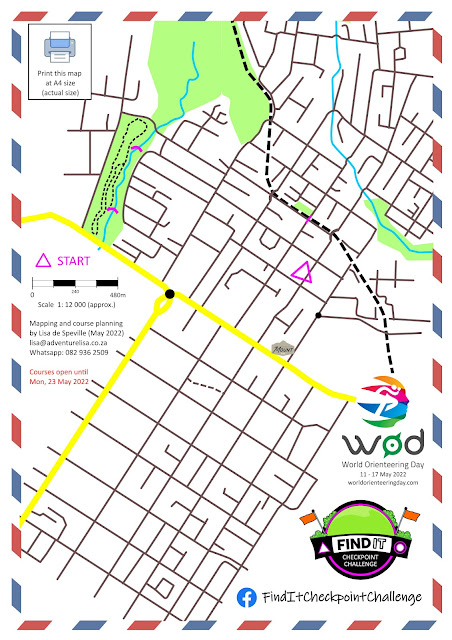
With this event, participants download and print a map in advance of showing up at the start location - a supermarket parking lot. The friendly cafe* there has allowed me to put the first checkpoint location card and event info and map in their window.
At each checkpoint postbox, they'll find a checkpoint card. It shows the location of the next checkpoint. I also added in the actual running distance to the next checkpoint. At CP 11, the two course distances split. The long 12km course goes on to bag a few more postboxes while the short 8km course goes to the final checkpoint and then the finish.
The route isn't really navigationally challenging with direction change and interesting elements because the focus is on visiting postboxes within a reasonable course distance. But, without street names and being an unfamiliar activity, it is sure to keep participants entertained and stimulated. For sure, most participants will never have run around with a map in their hands. |
| This is the map. Participants fill in CP locations as they progress around the course. |
* The friendly cafe I mentioned above... This is where I saw the announcement just over a year ago for the City Nature Challenge - on their window. That event introduced me to iNaturalist, which stimulated my observation and new passion for fungi. Since then I have logged 565 observation and identified 218 species. I told them today what the effect of putting a small poster in their window has had on my life.

No comments:
Post a Comment