Showing posts with label Forest Run. Show all posts

Sunday, 20 May 2018

First running of Not Forest Run

With my time overloaded and consumed with work, I made the call earlier in the year not to hold my Forest Run event. Presenting a race is not just the on-the-day commitment, but also the months of coordinating land permissions, volunteers, entry admin and a full week pre-race to cut, trim and mark the trails. I just could not do it this year and so cancelling the event was a relief. I came up with another plan instead...

Not Forest Run.

We have dirt roads all around Parys. You can mountain bike and run for kilometres - and it is all good scenery. I decided to replace Forest Run with a route that I had been wanting to do; something that would not need any organisation nor permissions and that I could also do. Not Forest Run, which we ran yesterday, is a loop route that starts and finishes at the Parys airfield. We ran on the open gravel of the Vaal Eden road, running past farms and venues and with views of the Vaal River and Vredefort Dome.

My morning started as Run Director at our local parkrun. I left early to get to the airfield so my friend and fellow RD Karen collected the equipment and processed the results. The morning was milder than I expected although the cooling wind picked up.

At the airfield I was surprised to see so many people. I was only expecting about six or seven but as Not Forest Run did not require any RSVP, I didn't know who to expect.

It is always a treat to have friends coming through. Allison and Tracey came through from JHB and Pretoria respectively, Amelia from JHB and Hazel also from JHB. Locals Bertrand and Michelle joined us. Ferdi, a local parkrunner, came along too. Then there were about five runners from Potch, recruited by Marilette. And another two or three, including Rachel and Angie, from JHB (recruited, I think, by Hazel). And a few that I recognised, but can't quite place, probably from JHB/PTA. Ruben and Celliers joined us on their bikes.


The idea with Not Forest Run is that you just have to rock up. This one started at 09h30. You run at your own pace. You are responsible for your own water and munchies. If you need to be rescued, you need to phone your own driver to come fetch you. Non running friends / partners were welcome to join on their bicycles.

I didn't mark the route but Celliers did ride ahead at the only real junction on the route where we need to turn left. He made a big arrow on the ground using some mielie meal.

Off we went, under a blue sky dotted with puffy clouds. We took the route anti-clockwise, straight into a headwind.


I hooked up with Hazel from the start - she met us on the road (which is why she isn't in the start photo). She had been dropped near the N1 highway and ran on the back roads to meet us (the thought it would be about 10km and ended up with a 20km 'warm-up'. We haven't seen each other for a while and, needless to say, we both have a capacity for conversation. If there had been any donkeys around they would have been legless by the end of our run.


The route begins with a long climb at a gentle gradient. This makes for harder work in the beginning and then a number of kilometres of flat and down thereafter. I really enjoy the section after the left-hand turn as the road winds a bit more.

Ruben on his bike.
I haven't run 27km straight for too long but the kilometres literally flew past. We did some walkies on uphills and gobbled up the flats and downs.

Selfie with Hazel.

Another guy was the only other runner near us and we enjoyed playing tag as he would catch us on the ups and we'd catch him on the flats and downs.

Hazel striding out.

Wildebeest just hanging.


Hazel strikes a pose
Ruben and Celliers caught up to us a few kilometres from the end. Both very chipper - they enjoyed their outing and were good at keeping an eye on the runners.

Ruben and Celliers.
Back at the airfield we enjoyed chats, hellos and goodbyes as runners came in and headed off back home or to enjoy the festivities of Parys. Before we left, Celliers went out in his bakkie to check on the last two runners. They were only 3km from the finish and both had supporters waiting for them at the finish.

This was a really superb Not Forest Run and one that we agreed could be enjoyed more regularly. I suggested seasonal (spring, summer, autumn and winter) runnings of the route to appreciate the changes in the scenery and to commit to myself to get out there a few times a year. Good idea.

Thank you to all the runners who came through to enjoy this run with me and to Celliers and Ruben for being my crew.

Monday, 16 April 2018

I rode my bike (on the Not-Forest-Run Run route)

I haven't been on my bike for ages! On Saturday afternoon Celliers and I hit the Vaal Eden Road for a zippy ride. Even though the seasons are changing, it is still stunning and green out there with wild grasses and flowers that make the fields and roadside look pretty. It was super to be out there on my bike with Celliers. Been too long!

The route we did is the one that I'll be using for this year's Not-Forest-Run Run. As I'm not hosting the actual Forest Run this year, I settled on a social and casual alternative that allows me to run too. It's a rock-up-and-run setup.

Starting and finishing from the Parys airfield, the route is 27km in distance. It is all on dirt road so the going is easy - except for the distance. You can zone out and enjoy the scenery without having to watch your footing.

Running out Parys parkrun at 08h00 is options.
Run starts from the Parys airfield at 09h00 for 09h30 start.

I'm really looking forward to it.

Here's the route map on Google Maps.


Tuesday, 30 January 2018

I'm postponing Forest Run 2018 (but you can still come run with me on 19 May)

I have decided not to present Forest Run in May this year. As you know, in March last year I started a new company YOLO Colours. Our main product is the fabulous YOLO Compost Tumbler. The first few months were slow (as expected) and then it picked up after Decorex in August. I’m thankful that January has been very busy. I’m doing Homemakers Expo in late Feb and so things should go up another notch. Plus, I’m involved with project #2, which has a tight deadline.
I am already sleeping too little and I just can’t see my way to having a week to cut and mark trails before the event much less the many, many hours of organising, coordinating and admin ahead of the event.
By this time next year my business will be more established and, I hope, will free me up to play in the hills of the Vredefort Dome. I had all kinds of plans for this year, like a new shorter 8-10km route, but I’m just not getting around to it.
I’ve had five consecutive years of Forest Run and so this break is actually well timed.
Even though I won’t be presenting Forest Run on 19 May 2018 as planned, I would like to invite you instead to join me on a dirt-road run just outside of Parys town on this same day.
We’ll start with our Parys parkrun (5km) at 08h00 (I’m the Event Director here) and then we’ll drive to the airfield (5km outside of town), park there and then run what we call the ‘Vaal Eden Road loop’ (25km). OR, start running from parkrun (about 35km for the loop).
(You don’t have to do parkrun and you can start running from town or from the airfield. I’ll send out a map.)
No charge. No entries. No RSVP. Just read my instructions and show up.
I’ll post details here and on the Forest Run FB page and website.
Bring your own hydration pack and snacks. You can run at your own pace (route is easy to follow, terrain is uncomplicated and scenery is great). Your friends/partners who don’t run are welcome to join on bicycles.
I hope to enjoy your company on 19 May 2018.
xxx
Lisa

Monday, 22 May 2017

The magic of Forest Run

The 5th edition of my AdventureLisa's Forest Run took place on Saturday and we were blessed with the most perfect weather and a field of friendly and enthusiastic runners.

It is never easy out there - the Forest Run route is fairly technical and challenging. And as the day warmed up, the runners felt the heat.

What certainly makes Forest Run so very special are the people. The marshals are mostly made up of my friends and family, sometimes past runners, current runners' partners and sometimes strangers who hear about Forest Run and offer to volunteer.

In order of appearance on the route my magical fairies and elves this year included: Liz (my mom), Celliers (my fiance), Penny, Tersia, Sylvia, Andy, Maggi & Marcel (photographers), George & Joan, Sonja, Sarah, CP, Hugh & Taryn, Louise & Jan, Fred, Lizzy, Martie & JP, Karen, Tanja & Jacques, Warrin, Sharin, Duncan, Isaac & Lloyd (medics).

Martie made the delicious date squares this year. We've all eaten too many of them!

My mom Liz always puts in double-time on Forest Run, especially in the week before the event when she prepares meals for marshals, lunch packets for marshals (assisted this year by Martie) plus the food for the aid stations. It is a lot of work to shop, prepare, organise and pack everything and she does it so beautifully. She is also in command of the finish - recording the runner numbers and times as they reach the finish.

Celliers is my right-hand on the day and he keeps an eye on the waterpoints by dropping off marshals and driving through to check on them. We have little cell phone signal in most places of the route so it helps a great deal to have him doing the rounds.

Karen has helped me hugely this year with trail cutting and trail marking and she was out on the far side keeping an eye on the runners. We had a few issues with baboons taking down boards and markers in the week and as she knows the route as well as me, it was reassuring to have her keeping an eye on the spot where we know the baboons have been.

My marshals themselves... Some have been at Forest Run before - not just here but when it was out at Lakenvlei. They all have event experience - either from organising or a lot of participation or both. It so helps to have a team of people who have been at events before - who have been at this event before. With limited comms out there, I need people who can make decisions, deal with situations and who are adaptable to any situation that develops. They give me the freedom to stay at the finish to welcome the runners in.

Various marshals sweep from their points to collect the boards and tags that we put out. Sonja, Sylvi, CP, Sarah, Fred, Lizzy and Hugh cleared the route as they worked their way to their exit points. There is only one short section that doesn't connect with start-exit sections, which I'll clear this week.

Maggi and Marcel are my magical photographers and they'll be posting their photos on the Forest Run Facebook page in this week.

I left my fairy skirt at home on race day - in my hurry to leave the house I left it hooked over a chair. Nothing that some fairy wings didn't sufficiently remedy, but I did miss my skirt.

At the finish with two locals - Gerhard and Sean.
And then the runners. I'm sure Forest Run has the nicest collection of runners ever! This year I gave telephonic entries a try and many entrants went for this option - so I felt as if I knew many of them by the time race day arrived as we'd already 'met'. In addition to the usual email-entry-form entries, I also had entries by sms and whatsapp and Facebook Messenger! It was a bit of a juggle but actually worked really well.

For now I've got the results to type up, a report to write, runners to email, landowners to thank and a date to set for Forest Run 2018. I'll post a selection of my favourite photos later this week.

xxx

Tuesday, 25 April 2017

Hiking with dogs

On Sunday afternoon I hit the Forest Run trails again, but this time with Rusty, my mom Liz and her dog Tansy.


My mom got Tansy almost a year ago when this little dog was abandoned down the road from her house. Tansy was well groomed and had probably only been out there for a while when my neighbour picked her up and went walking around looking for her owner. That's when my mom saw Tansy and it was love at first site. My neighbour took Tansy to the SPCA and my mom phoned first thing the next day to see whether anyone had claimed her. Nothing. Two weeks later, still nothing. My mom then adopted this one-eyed maltese.

Shortly after getting Rusty Celliers says to me:
"I'm not sure whether it is real or whether I imagined it... or if it was a rumour... but I thought that you and your mom were cat people?"
He's right. We've always been cat people. I definitely inherited the cat thing from my mom as I've had a cat in my life almost non-stop since I was born. She always had a cat from when she was a child. Bracken's passing, this time last year, broke our hearts.

There have been dogs that we've liked - like my husky friends Angel and Toscana and, more recently, my dear husky neighbour Kiska (who is no longer with us). But, for the rest, we've been through and through cat people.

Now, nevermind dog or cat, I'm a Rusty person. A total convert. I even kiss her and I don't wash my hands every time after I've touched her. Same goes for my mom. She's a Tansy person now.


I was so impressed with Tansy on Sunday afternoon. This was Tansy's first hike and this little one-eyed white dog with her little short legs proved to be a hiking enthusiast. She walked the entire route (about 5km), scrambled over rocks and under branches and even crossed little streams. Mom carried her across the first stream and after that Tansy did the rest on her own - even hopping across the rocks on her return route. It is a delight to watch the enthusiasm of this little dog with her big heart.


Rusty loves the trails and is an excellent path finder. She doesn't like the sound of the baboons shouting from the hills but she'll get used to it.


Rusty will come out with me next week for four days of trail cutting and clearing in preparation for Forest Run on 20 May. Not long now!

Sunday, 16 April 2017

Rusty on the Forest Run route

Yesterday Rusty came out with me, Celliers and our friend Marinus for a lovely hike on a section of the Forest Run route. We start cutting the trails for Forest Run in two weeks so it is nice to keep an eye on how the area is looking before I have to jump in.

Rusty is only two-and-a-half weeks after her sterilisation op so I am very cautious of doing too much with her. We kept a leisurely pace and she loved it. I took her off lead and she was such a star. She stayed with us - never going too far ahead so that she could look back and see us. She is an excellent trail dog.


The first part of the route that we did isn't on the event route. We took an old track that has recently been opened up to the top of the hill. Great view!


We then headed off the hill and onto the Forest Run route. This is a section that only the 30km and 46km routes go on.


What was so amazing for me was to see the streams running. I knew there was water here before the drought but this was the first time that I've seen the streams with water - it was magnificent and I fell in love with the area all over again. Rusty enjoyed a drink and a splash in the first stream we came to.


We then went on to the Red Donga Trail, which I always enjoy. It was even better than usual as it looks even more like a place you'd find fairies and elves. Lots of green undergrowth through the donga.


We stopped for a quick break and snack.


I couldn't believe the amount of water flowing across the road at 'Butterfly Alley'.


We then popped into the Venterskroon Inn, my start/finish venue for Forest Run, for a colddrink and snack (they make divine chips!). Rusty had a snooze under the table.


I look forward to taking her out here more ;)

Forest Run comes up on 20 May 2017. Entries are open until 6 May. Come run - forestrun.co.za

Monday, 20 February 2017

A weekend away, 30 minutes from home

Celliers wanted to go away for this past weekend. I didn't. We're going away with friends in March and I had a lot to get done so I didn't want to miss out on Thursday and Friday and then be stuck in a car for five-plus hours to get somewhere.

Instead, I booked us one night away, at a most fabulous spot in the Vredefort Dome - less than one kilometre from the Forest Run start venue.

The week before I'd been out in the Dome, meeting with my start venue - the Venterskroon Inn - so go over details and also to get suggestions from Leon for other accommodation venues in the area to add to my list. He passed on a few names and the next day I phoned them, checked out their websites and added them to my map and Accommodation page on the Forest Run website.

Most of the places are self catering but the one, Desiderius per Flumen, offered dinner, bed and breakfast. I dropped Rassie a note to see whether I could book one of their four double rooms for Saturday night. "Yes," came his reply.

We went through in the afternoon after helping at our friend's trail run in the morning as marshals and route sweepers. Rassie warmly welcomed us before we headed through his most beautiful garden to gaze at the Vaal River. The house and garden overlooks the river. We then spent a few hours lying on wonderfully comfortable garden chairs, under the shade of a large tree, while we read, dozed and listened to birds chirping.

Rassie cooked us a delicious dinner - he is a whizz in the kitchen. If you ever stay here, ask that he makes you his potato wedges! We enjoyed a solid 10-hour sleep in the absolute stillness of the location and were treated to rusks and tea (for me, coffee for Celliers) and double-cream yoghurts before a delicious home-cooked breakfast. He sent us home with the rest of his early-morning, home-cooked pot bread.

After just one night away, we felt like we'd been away for days - and only a 30-minute drive from home. Celliers had no idea about what I'd planned so it was a nice surprise for him.

We then spent the rest of the day on the Forest Run 16km route. I had not taken Celliers up there before and wanted to show him the protea forest and the trig beacon. Even though I know the area like the back of my hand, there were parts that I totally did not recognise because of all of the vegetation growth - so different to this time last year when it was sweltering and dry. We will have loads of grass cutting to do come early May, to get these trails run-ready.

A couple of photos from the route.

celliers-trig

Celliers at the trig beacon.

interesting-rock

The Vredefort Dome is a meteorite impact site so the geology out here is amazing. We found this interesting rock. This section is not on the Forest Run route - we were exploring some other tracks.

no-track-visible

Last year, there was a track straight through here. We'll have loads of grass cutting to do ahead of this year's Forest Run on 20 May 2017.

protea

What a win! We saw a number of open protea flowers in the 'protea forest'. Online it says they flower October to January but it looked like there were still loads of flowers just waiting to open over the next week or two. That would be really wonderful to see.

view

Green and lush out on the Forest Run route. This is one of three steep downhills on the 16km route. Walk, take care and enjoy the view. Fortunately, it is short.

watermelon

My new 'watermelon' AR Mini Gaiters. Visit AR Gaiters website for the available prints and colours. We encourage you to go wild with cool prints. Once you've worn AR Mini Gaiters, your life will never be the same. Transform your runs, sock longevity, reduce blister risk and foot comfort on trails and dirt roads.

Monday, 27 June 2016

Forests and fairies

How is this for a hoot!

Chris Hunter, a Forest Run follower on FB, wrote this post this morning: 
"Ok folks, I'm the village idiot. Can you believe that for a number of weeks now I have tried to understand the relationship between the Forest Run and people dressing up as fairies.
So, on Saturday morning, while eaves dropping in on a conversation between a mum and her 4-year-old daughter, I realised my mistake... "Fairies live in the forest mum... dah!" 
Need I say more? So now my world is a perfect place once again and saved by a 4 year old..."

And there I thought that everyone knew that fairies lived in forests...


Wednesday, 25 May 2016

Fabulous Forest Run frenzy

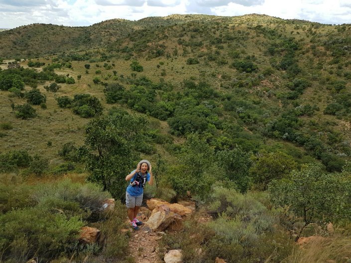
As you've noticed, I've had barely a moment to pen a blog. My past few weeks have been a whirlwind with preparing for Forest Run, the World Orienteering Day activities, drawing maps, trail clearing for Forest Run, presenting Forest Run, wrapping up Forest Run... I've still got the boxes from each aid station scattered around the house because I haven't had a chance to get to them. But, I will. Before Saturday... Because I'm off to Chile on Saturday!

It has been very challenging but also immensely satisfying to get Forest Run off the ground in its new venue. In the two weeks leading up to the event, there were very few nights when I didn't go to bed after 2am, getting only four to five hours sleep. I'm still recovering.

Forest Run map
Part of my preparation for the event involved drawing a map of the area with the trails, which helps with my preparation. I've created the map as a base for a rogaining-orienteering map as well as sections for hiking trail maps. I've still got work to do on this but the foundation - a good one - has been built. I look forward to planning a 'mapping party' with my orienteering friends to add more detail to the map.

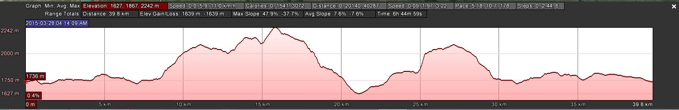
The 46km route map. Each route has its own map. Some of the route is on public hiking trails; other sections are on private land.
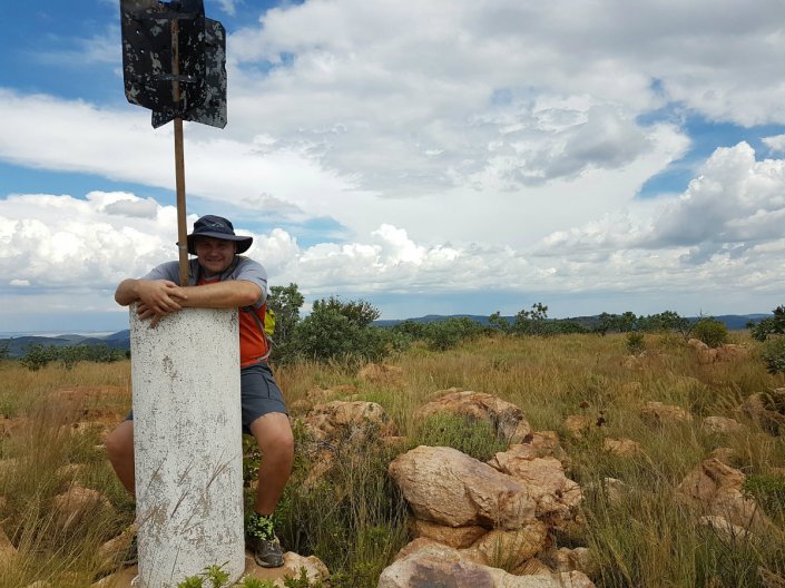
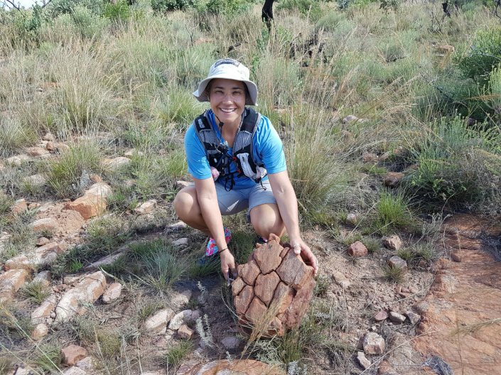
Trail cutting and clearing
Goodness! Did we have our work cut out! I was very fortunate to have Ricky, who works for my friend Karen, doing the brush cutting. We spent a full five days out there cutting sections of single track. While Ricky was cutting, Karen and I chopped overhanging vegetation, cut away shrubs encroaching on the paths and even rolled rocks out of the paths to improve the runnability of the terrain. We were joined on the one day by Warrin, who is really good at rock rolling.

I also spent another half day clearing a trail section with help from my mom. She got into vegetation cutting while I rolled rocks.

This clearing was definitely well worth the effort, not only for the event, but also to leave the hiking trails in a better condition than what we'd found them. They are not used much, but should be - and having clear trails will go a big way towards making the trails more user friendly.

Event Day
We had perfect weather: clear skies and temperatures that were perfect for running. 97 runners took part with only 14 on the longest 46km course and a mostly half-half spread of the rest on the 30km and 16km routes.

Aside from there being a few tweaks to make, everything ran very smoothly and I was fortunate to have a superb team of marshals out on the route -  a combination of friends from Jo'burg and new friends from Parys. All of them sporty and fit and experienced and capable. They kept things on track, even with the challenge of poor to no mobile signal on many parts of the route.

Feedback from the event has been very positive - from the friendly marshals to the challenging routes and terrain. This area is very special and Forest Run should be making it into people's calendars as a must-do event that is definitely not easy.

Friends Maggi and Marcel took photographs - they have so beautifully captured the area and the spirit of the event. The photos are in albums on the Forest Run Facebook page.


From the start I was warmly welcomed by our host venue, Venterskroon Inn. I can totally recommend that you head out there for a Sunday lunch. Even when I was concerned about low numbers of runners a few weeks before, Leon was totally positive. He and Pearie made sure that everything was just right and have made me feel at home from the day I first mentioned it to them.

I have also been very warmly welcomed by the landowners. Forest Run traverses a number of farms and every single one of them agreed, without hesitation, to literally give me the run of their land. As with the hiking trail, I aimed to leave my routes on their properties in better condition than I found them and look forward to further exploring the area and developing my map (for their use too).

Wrapping up
I've still got boxes lying around the house that I need to attend to. But I have answered dozens of email, compiled the overall results (still to add all split times), written and article and spent hours tagging photos on Facebook. hahahaha

Months ago I'd decided to make a per runner donation to a school in the event area and today I went to visit Mponeng Primary Farm School. It's a small, rural school on the Venterskroon road. I'd heard about Rene and the incredible work she has done with the school - today I saw it with my own eyes.

For me, it is important that Forest Run has social and community involvement. As I've spent a decade involved with aspects of school sport - from rural development and social responsibility programmes to city school sport and coaching. Thus, my decision to select a school to support.

Their principal, Rene, is energetic, dedicated and inspiring.

Me with Rene.

Their weekly menu. One lady prepares the meal daily to feed the almost 100 children at break time. As Rene says, "She creates magical meals out of almost nothing". This is the menu issued by the Department of Education. For most of the children, this is their only meal each day. Rene told of a little boy who one Monday morning passed out in class. The meal he had the Friday before at school was the last one he'd eaten. Sadly, that's the reality for many children.
Some of the little children walking from their classroom during break time to the kitchen to receive their daily, cooked meal.
The school's wonderful vision. As you know, I've never been into any god nor religion so my only edit to this would read, "Enable learners to become contented, honest and respectful persons in their community with the certainty that they are valuable to themselves and others."
They have five teachers and around 98 children from surrounding farms. They have also opened their doors to street children, who they are educating and teaching to read and write. Children range from 3 to 19. The school has a wonderful energy and warmth and it was a treat for me to visit their children and classrooms.

I look forward to building a relationship with the school in both my personal capacity and with Forest Run.

There is an overwhelming amount of need. From animal welfare organisations to those that care for children, disabled, elderly... Mponeng... it's a small school on my doorstep that is positively influencing the lives of these little children, who didn't ask to be born. So many of them come from bad homes with neglectful and abusive parents. Being at this school means that these children have a chance. To change their own lives.

I look at my instant family and two children that don't want for anything. They have lovely bedrooms and warm clothes and three meals a day. That all children should have this.

With Forest Run almost behind me, I'm starting to get excited about my next adventure... CHILE! (more in my next post).

Tuesday, 19 April 2016

Brown squiggly lines bring bliss

I know how to use OCAD - orienteering map-making software. I'm not the most proficient nor practised as I don't map very often - and I haven't mapped any seriously tricky terrain. I've modified other people's maps and I've drawn my own maps of schools and a park. I'm busy with my first river map (mapping the bank features and islands) and a map of a primary school here in Parys.

My next project is to create a basic orienteering map for Forest Run. It serves a couple of functions:

  • A hand-out to introduce participants to the delights of a map and knowing where you are. Yes, the route will be fully marked, but I like to think that runners may enjoy knowing where they are. Of course they can tuck it into their backpacks and leave it there...
  • A guide for my marshals (many of whom are orienteers) to get to their marshalling points - and for sweeping the route.
  • For safety: this special version for my marshals and medics will show escape routes and accesses.
  • The start of a wonderful map for technical, long-distance orienteering events and for rogaining, a long-distance, time-limited form of orienteering - my favourite-favourite.
For now, this will be a really simple map - I'm short on time and a complex map is not required just yet.

In order to create an orienteering map, one needs a base map. We generally use orthophotos, which have been corrected for distortion and they carry contour lines, which indicate elevation and topographical features. Google Earth screen shots do work - for small areas - but there are no contours. 

Fortunately, being in the modern age, we can get digital aerial imagery and also digital contour lines; both of which can be georeferenced and imported into OCAD.

I've never had experience with this.

Until today.

OMG! My heart runneth over with bliss. And I can give full credit to Stephanie, who supplied me with the necessary files - all beautifully georeferenced and ready to go. Sarah R and Paul were also on hand, offering assistance - thank you. Nic, with his OCAD experience, got me to the final stage of success tonight - getting my GPS track in.

And so it was that I successfully imported the contour line file. With counsel, I got the background images in (13 x image files at 285MB each!). And I've just experienced the joy that comes with importing a gpx file and successfully positioning it so that my track for the routes is in the correct place. Oh, what joy!

Now the work starts - to turn these squiggly lines into something that can be read and interpreted. 


Friday, 15 April 2016

Altitude profiles are relative

In drawing the altitude profiles for the Forest Run routes last night, I had to decide on the best way to present the route. What kind of elevation scale was I going to use?

The challenge is to indicate that there are climbs and descents - some of which are steep; but not horrendously so. Out here in the Vredefort Dome, there isn't anything too nasty, other than the sting-in-the-tail descent near the end. No climb nor descent goes on and on; but they're still there to test you.

I plugged my gpx track into Google Earth and also used two online apps to compare profiles and also for them to calculate cumulative climb. Although the results vary, I think approximately 1330m of cumulative gain is fair for the 46km route at Forest Run.

Here is my profile for the 46km route:


So, how does Forest Run compare?

Well, Dorothy, we're not in the Drakensberg Mountains, the Witteberg Mountains nor on Table Mountain. But we've still got some climb.

Distance (km) Cumulative climb (metres) average climb (m/km)
Forest Run 46 1330 29
Rhodes Run 52 1380 27
Skyrun Lite 65 2400 37
Drakensberg Northern Trail 40 1640 41
Ultra Trail Cape Town 35 1800 51
The Otter 42 2400 57


I couldn't make a profile for Ultra Trail Cape Town as they don't show a y-axis elevation scale on their altitude profiles. I did grab profiles from these other events - and I've scaled them appropriately to compare. That's Forest Run with the grey shading.


The thing with cumulative climb values for events is that ascents are... cumulative.

Looking at my average climb (metres per kilometre) calculation, The Otter beats all the others for its up-down-up-down of its route, even though it doesn't have the massive and steep ascent of Skyrun Lite nor the big climbs of Drakensberg Northern Trail. Rhodes Run, like Skyrun Lite, also has a big climb, some stuff in the middle and then a long and steep descent.

Of these runs, I've done Skyrun, Rhodes Ultra and Forest Run. For sure, Skyrun is the toughest on the legs and lungs on the ascents; and that's a long long long steep steep steep drop into Balloch. It also has some wicked thigh-burning climbs in the middle.

Could this Forest Run route be harder than Rhodes? Mmm... It has been a long time since I did Rhodes and I had a superb day out there so even considering Rhodes' Mavis Bank and the drop into the hamlet of Rhodes... Definitely not an apples-with-apples comparison.

Climb really is so different on the legs if you have one big climb or lots of smaller ups and downs.

Also, it isn't only the elevation that makes a route challenging, it is also the underfoot terrain.

And how hard you're pushing.

And the actual elevation (height above sea level) of the route. There's a big difference in scaling a steep ascent at 2500m than at sea level.

Here are the altitude profiles for these same events, as presented on their websites. Take note of the elevation scale on the y-axis.

Drakensberg Northern Trail - recent host to the SA Trail Champs. 40km. Each elevation mark is at 250m intervals.

Rhodes Run. 52km. Elevation is in 100m intervals. This looks like you climb Mavis Bank on all fours... Oh, wait, some people do!

Skyrun Lite 65km (route ends at Balloch, in the dip before the spike at the end). Elevation is in 500m intervals. Looks a lot more tame here than on my profile scale.

The OTTER. 42km. Elevation is in 10m intervals. Very spikey, which ever way you look at it.
Of course, I could have presented a more flattened profile for Forest Run - I think this actually looks more like reality if you're looking at the hills.


Next time you look at an altitude profile, don't stress if you see big bumps. Take a look first at the altitude interval on the y-axis and compare to something you've done before to put it into perspective.

Altitude profiles really are an indication - not a definitive guide to the difficulty of an event.

Regardless of the climb, you've got to do the distance. So just jump in, enter and enjoy the experience of the route, terrain and scenery.