Showing posts with label orienteering. Show all posts

Sunday, 4 May 2025

49 Days of Running

My annual pre-birthday challenge starts a day earlier each year, and this year 1 May marked Day 1. This time around, Day 1 happened to be the first day of the Western Cape Orienteering Festival - four days of orienteering.

I had three participation days, which I've written about in separate posts (Day 3 still to come), and today, Day 4, as course planner for the sprint event.

A beautiful morning for orienteering today. 

This year I'm going to stick with same-same with a 4km/day challenge. It worked really well for me on top of my other activities of dog outings and crossfit. I certainly averaged over 4km/day last year, which is fine. But on those crazy days, getting out for 4km is doable.

Last year's birthday challenge really worked well for me after about three years of poor running. I felt great coming odd the challenge and built on that over this past year. I've been feeling really good. 

Today, my Day 4, I don't think I did quite 4km. I did run around this morning putting out some controls and then afterwards collecting controls. 

I've got a sore left knee and inner thigh muscles after a overextension slip-and-slide in the forest yesterday during orienteering. I'm going to nurse this for a day or two and see how it does. I was quite sore and limping by the time I got home today. If I need to substitute Day 5 run with something low key, so be it.

So, here begins 49 days of commitment to me. Hip hip hooray

Friday, 2 May 2025

W. Cape Orienteering Festival Day 2

Day 2 was a middle distance course and while it did not over a big area, it was pretty tricky because of the straight-line forest navigation and sketchy vegetation features.

After yesterday's OK, but not exemplary run, I was a bit more cautious today. That my first control was slightly dodgey, I was even more cautious for the rest. 

Overall, my navigation was actually pretty spot on. I wasn't feeling confident and the terrain was such that I walked, tramped or sort of jogged. This did allow me the pleasure of seeing hundreds of fungi. Loads of Russula (brittle gills) and more deliciously edible boletes than I have ever seen. I actually stopped briefly to look at the biggest one I've ever seen - way bigger than my hand. If my phone had not been in the back of my backpack I would have taken a photo.

There were really only two errors that I made today. The rest were just cautiously slow. I didn't have to hunt for any of them. 

Control 1
Man, I hate messing up the first control. 

I didn't want to chance an uphill and forest vegetation so I ran around on the road, taking a bearing from the bend. I overshot and I was a bit to the right. I decided to turn around, get back to the road and try again, when I pretty much walked on to the control. 

This shook my confidence a bit and set the stage for the rest of the course. While I walked on to most of the controls and didn't have to hunt, I wasn't really trusting and felt what was almost surprise when I found the controls where I thought they should be. Haha so silly even after all these years. 

Controls 5 and 6

I came into 5 a bit low, saw the road, which I knew I shouldn't be seeing. I can only say that it was with luck that I was in the right alignment to walk deeper in and just find it. 

I'm then not sure what caused me to make my next mistake... 
I took a bearing from 6 to 7, thinking that I was at 6! I got to the road, realised that I should have been going 5 to 6 and not 6 to 7. So I ran on the road and then ducked into the forest and got the control. That would have been bad if I'd missed 6. 

That was really it for any drama today. 

I found that the nav today took a lot of focus and attention. I used my compass for pretty much every control and really tried to use direction, contours and vegetation to hit them straight. 

Hilton beat me by two minutes. He had a big error that took him about 16 minutes to find a control. I didn't have any of those big mistakes but most of my controls were a bit slower than his. 

Jacori had a good run. She beat me by almost 5 minutes. I think she had two big errors but was consistently quicker on the rest. Over 18 controls, a minute faster here and there adds up. 

Tomorrow is the long distance event. I'm hoping that these two days were warm ups to tune my brain into focus. 

Thursday, 1 May 2025

W. Cape Orienteering Festival Day 1

The first day of the Western Cape Orienteering Festival took place at Royston Farm, where I did the run-mtb-run event two weeks ago. Still, orienteering navigation is very different to Google Earth map navigation so I knew the course would be challenging.

Overall, my nav was OK, but I did make a few less desirable choices. I wasn't particularly focused, for whatever reason, and it showed as a non-competitive run. 

These are the odd things that I did:

Control 3
I came in a bit low to #2 and then not wanting to chance the green vegetation, I ran around. At 3, I first went in from a bend in the path and didn't find the control where I thought it should be. Shock and horror. 

I went back to the path and ran around a bit more - the control was visible from the path.

Control 3 to 4
The easy route was to run on the trail that runs parallel to the road (yellow). I cycled this two weeks ago. So I decided to rather take the trails. This was definitely slower, but was new terrain for me to discover and demanded that I pay attention to the map.

Control 5
Approaching 5, my first thought was to go from the corner of the road, but then I decided to rather get closer by taking a bearing from the bend in the path.

I suspect that I didn't go far enough before starting to look for the control when I didn't see it where I thought it should be (thicket). I looked around for a bit and then took myself back to the road and the corner, took a bearing and I walked straight to it. 

My Strava track shows that I may have even passed it nearby. 

From this, it looks like I wasn't quite at the bend and that I went in too soon... But this is probably a map-track offset as it doesn't show me coming along right on the road, from the right, which I did. 

Control 7
For the route to 7, the fastest would have been to take the trail that I'd come up on (yellow) but instead I took the zig-zaggy trail. It worked fine but was definitely less efficient. 

And that was it. Moving slower, being way too chilled and these errors cost me. 

Hilton finished 22 minutes faster than me and Jacori 10 minutes. 

I'll really need to focus on the long event on Saturday. 


Monday, 21 April 2025

Lettuce's run-mtb-run nav event

 I had the pleasure of doing a run-mtb-run navigation event yesterday morning, hosted by James 'Lettuce' Stewart at his Royston Farm just past Plettenberg Bay. Two friends, Talita and Otto joined me there, and it was a treat to see other friends like Debbie, Jeannette, Christine and John. 

I'm so glad that Otto and Talita are enjoying navigation activities.


A pre-start photo with Debbie. 15 years ago, in the early 2010s, we did a number of the Kinetic Sprint races together. 

We started with a 1km orienteering activity -  a quick loop around the start area to find a number of checkpoints. We then got ready to bike, copying checkpoint locations from a master map on to the Google Earth images provided.
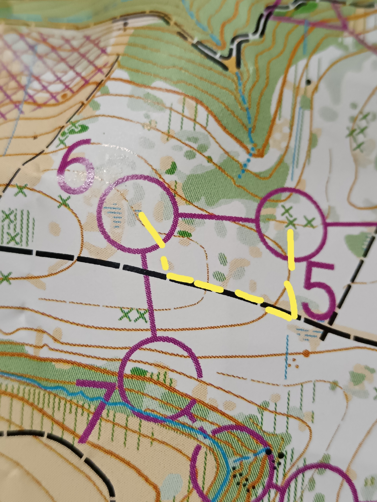
CPs 1, 2, 3 and 4

I decided to hit CPs 1, 2, 4 and 3 first. Otto and Talita made the same decision and we were together through 1 and 2, splitting before 4. I initially thought I'd get #3 first, because it looked like an out-and-back ride from what I could see on the map. Ideally I would have wanted to connect #3 and #7...

They split off first to go to #4; I split a bit later, deciding to get #4 first in case I could take another route from #3... I wouldn't see Otto and Talita until much later.

All was good. Laving #3, I did look for something to the right - like where I've drawn in the yellow dots. I didn't see anything that looked like a trail so I continued on the good dirt road all the way around.

CPs 9, 8, 7, 6... 


Heading east from #2 and looking ahead at route options, I could see what looked like a trail parallel to the highway. Before getting there, I spotted a trail going into the blue gums off the dirt road, so I took it. It worked out well and popped me out on the dirt track. I then took the trail parallel to the highway.

#9 was easy, just off the road.

Going to #8, I planned to take what looked on the map like a track between forest blocks. This is an old map and according to current growth, it doesn't look like this. I saw Jeannette and her teammate here - they had turned around and she said there was no road down the bottom. I checked and turned around too. I did see a ride* in the forest but not knowing quite where it was, I didn't want to chance taking it.

* A ride is a gap in the forest - probably used when planting and later when felling. It is like a row of missing trees. Good for travel.

I rode around instead and as it turned out, the CP was on what was probably the same ride, so my possible route from the other side would have worked out.

#7 was straightforward.

Then on to #6, which was labeled as a tree on single track. I got the CP and then decided to stay on the single track to see where it went. I knew it would hit the dirt road that I could see at some point. It hit the dirt road before the dog leg - all good, I knew exactly where I was.

This is where the fun starts

The actual map is printed a bit darker. I've bumped the brightness up to see more in these images.

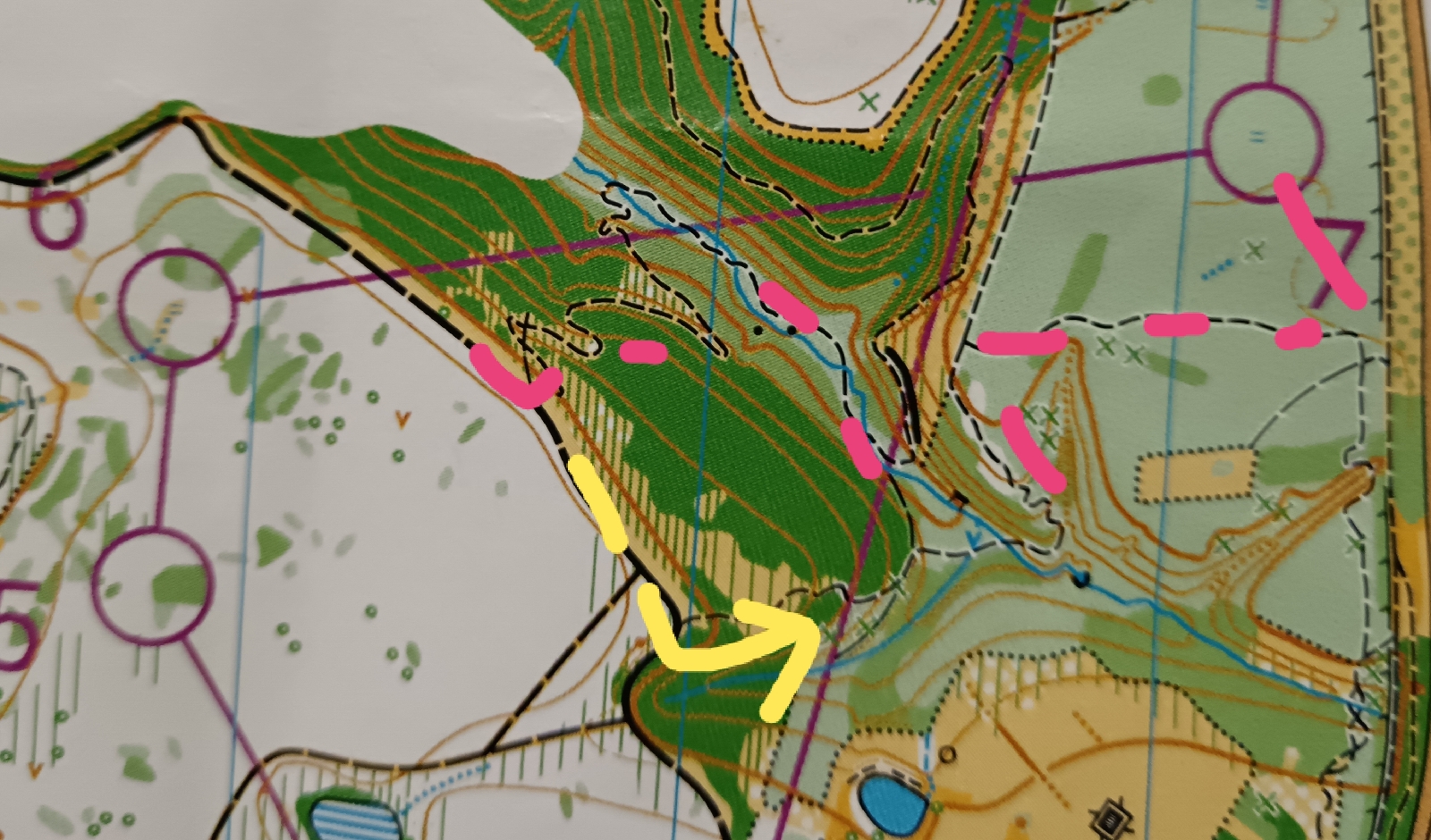
Riding on the open forest road from 6, I spotted a trail off to my left (north), which gave me two route options.

The first was to ride back the way I'd come (green arrows), past #9, on the trail parallel to the highway and then to CPs #10 and #5. This was safe and quick.

I looked at the control description for #5 and it said 'Sneaky path'. To me, this suggested that James was indicating a trail that connected the ridge that #5 was on with the ridge which #6 was on (yellow dotted line is what I hoped for). As I could see a clear trail going down, I figured it would be worth a try.

The trail snaked down and at the bottom - next to a stream, I could go left and right. I chose to go left, which was a clearer, more used and worn trail. Should have gone right. haha haha

The trail was spectacular riding with dozens of bridges to facilitate the trail criss-crossing the stream. I loved the mosses on the trees and logs and rocks, gentle rocky stream, meandering trail, sufficiently wide bridges and interesting rocky cliffs. After about 1km, I did think it would be worth turning back to try the right-hand option, but as the trail was really fabulous, clearly new and that James had mentioned a new trail, I figured it had to turn up at some stage to get out of the valley to return to Royston Farms.

I kept riding and knew I was far down but the trail was awesome. Eventually it started to climb out. 

The pink trail that I've drawn in is my estimate of where I was. I do have a Strava track that I'll capture once I finished writing this. A 'game' that I enjoy post event is to draw in where I think I was...

Thinking that my friends Talita and Otto were probably long at the finish, I sent a whatsapp to Talita to say that I was fine and that I'd taken a trail in the valley but that I was climbing up now.

She replied to say that she thought they had done the same.

Not 100m later, I found them ahead of me! 

Back on the ridge, we cycled to #5 then #10 and to the finish-transition.

I told James that I'd ridden the 'Trail of 100 bridges'. He looked at me quizzically for moment and then laughed, saying I'd now be hiking it from the other direction. Haha haha.

Joined by Otto and Talita, we set off, running and hiking the route we'd done in reverse, this time continuing on the right-hand trail.

Another funny trail


We got the 3rd and final hiking checkpoint #3 and turned around to get back on the trail. I expected a forest boundary and I'd seen a track where I have the dotted yellow line when we'd ridden from #5 to #10. I expected the trail we were on to merge or intersect. I either missed it or it wasn't there and so we followed a very good footpath that meandered. We cut through the forest, hitting the road in front of the finish.

Our final activity was walking across a swinging balance beam, and then to the finish.

James cooked us egg-and-bacon breakfast buns - I just had two expertly fried eggs, and we got a slab of chocolate each - it was Easter Sunday after all.

This is my actual Strava track.

33km logged

The new trail through the valley is an MTO trail - they are doing the trail building. It is superb - I'm really glad that I did ride - and hike - it. 

This was a really super morning out - good fun and wonderful exploration.  


Wednesday, 3 January 2024

Big 5 O Week: Day 5

 The last day of the Big 5 O Week (big5-o.co.za  and Big 5 O Week on FB)  took place in my home town of George. With this event being in my back yard, event director Nicholas Mulder asked if I would be the controller for the event.

Every event has a course planner and a controller, where the controller is there to cast an eye over the courses, give it a second look and suggest any improvements, if needed. As this was a sprint event with World Ranking, we also had Paul Wimberley as the WRE advisor.

Being in such esteemed company, there was not much that I had to do in an official 'controller' capacity as both Nic and Paul are leagues ahead of be in course planning experience.

What I did assist with was organising marshals for the road crossing and to keep an eye on the control flags in the public section of park, and also putting out the control flags and timing blocks with Paul.

As soon as we were done with Day 4's event, Paul and I headed back to George. We started putting out the controls in the Botanical Gardens, which is a safe, fenced property with no chance of our flags going walkies overnight. For the public accessible areas in the forest and park, we put out only the metal stakes. We did this between 5pm and 7pm and unless you know where to look and know what you are looking for, the stakes are not very visible. With 68 controls out there for this event, it takes time to get them all in.

We were up at the crack of dawn on the morning of Day 5 to get the flags and timing blocks out. We were done with this by 7am. Paul then did a quick run through the Botanical Gardens to check that everything was still in place. 

My friends who volunteered to marshal were absolute gems. Etienne arrived early and he was tasked with keeping an eye on the flags at the bottom of the park, which would be the most at risk between the time of being put out and the first runners coming through. Johann stood at a washout section that would be more difficult for the older participants to cross. Zelda, Talita and my mom Liz were at the road crossing, stopping cars to let the participants run across without losing time. The participants so appreciated all of them and were very complimentary. Thank you friends.

The weather was overcast with low cloud the whole day so the participants did not get to see the beauty of George with the mountains keeping an eye on the event area.

This is what Paul and I saw on Tuesday afternoon while putting out controls in the Garden Route Botanical Gardens. There was not a mountain or forest to be seen on Wednesday.

As soon as the last runners were through, we started picking up control flags in the park. With help from Etienne and Michelle, we quickly cleared the park and made it to the finish in the middle of prize giving.

I was delighted to hear that I won the age category that I competed in - W35. We got together for a photo.

Stephanie (left, 3rd) was one of the organisers, putting a huge amount of work into the social functions, trophies, prizes and a host of important elements. Jacori (right, 2nd) from Cape Town beat me on Day 3 with a cleaner run. I was only just ahead of her on Day 4. 

This has been a wonderful week. Exciting news is that SA Champs is down this way in late September, using these new maps. This will be more Plett side, using the Day 1, 2 and 4 maps. It would be well worth going through to the Western Cape Champs in Cape Town - this is probably in late April or there abouts.

Now that we have a superb map in George and excellent maps nearby - plus a number of orienteers now living in the surrounding area - between The Crags, Plett and George, it is about time that I got organised to run some navigation training sessions and then a local event or two. We have an old Saasveld map that I can update and a few fabulous schools that would make for good venues. 

Three cheers for more orienteering in 2024. I am very, very thankful that Big 5 O came down here this year. The next one will be end of 2025 in the Cradle of Mankind area on the highveld.

Tuesday, 2 January 2024

Big 5 O Week: Day 4

Day 4 at Big 5 O was a decent, clean run for me. Listed as 6.6km as-the-crow-flies with 180m of elevation, I ran 9.5km with 199m of climb. 

After Day 3's mess with Control 1, I took it steady and focused to the first control, not wanting to mess up. This now only wastes time but also messes with your confidence if you don't hit the first control correctly. I had a good one to Control 1. Big sigh of relief.

I could have run or moved faster on sections, and there were parts where I could have taken the tracks a little more - but I straight-lined to challenge myself. But with the exception of my rout from 8 to 9, I was pretty happy overall with my choices and progress. 


This was a map-flip course. When I got to Control 14, I turned over my map for the next part of the course. 


Strava route in red with what I think I did in pink. It is a fun 'game' to try to remember afterwards exactly where I went, past which features, for each leg of the course.

This was my last participation event - four of the five. For the 5th, I'm controller and will assist with putting out controls. 

It has been amazing to be doing orienteering events after so much time away and also to see the people in the orienteering family. I am friends with many on Facebook but haven't seen a good number for many years. It has been wonderful to be with them again.

Sunday, 31 December 2023

Big 5 O Week: Day 3 (Middle)

 Day 3 of Big 5 O Week, in the Harkerville area, was wet. The gentle rain and mild temperature were quite fine for running. It was really squelchy for the day's organisers for hanging controls and setting up the start and finish. Those of us wearing glasses struggled with fogging up and not being able to see anything.

This was so far my worst day of the three, especially as I messed up the first control, which was not at all difficult. I came into the control 5-10m below it and just didn't see it. I wasn't sure how I'd messed up and it cost me time to figure it out. Actually, I messed up almost right from the start when I decided to run on the road, then chastised myself for not taking a straightline and I then cut across the forest, which was good terrain but slower for me than running on the road. I hit all the other features until I dropped into the ditch.

Drawing in my route.

Something that I have realised across the three events is that despite not having done any orienteering events for 8 years, with the exception of two or three rogaines (last one in about 2018?) my navigation and compass work are pretty decent.

Where I am compromised is in my speed of weighing up route choices and relocating if I mess up. I haven't had to do much fixing of mistakes, but my indecision and sometimes less optimal choices have cost time. After messing up Control 1, I spent more time checking and rechecking myself, my confidence shaken. Just out of practice.

I ended up second in my age category - three minutes off - and far down on the overall course results. Arrrggghhh!!! Win some, lose some.

Route comparison overlay of the route that I drew in that I think I took (pink) and the Strava track (red).

I need to pull up my AR Gaiters for Tuesday's Day 4 Long O. This will be my last event as I am controller for the 5th and final event in George on Wednesday, so I want to make it a good one.

Saturday, 30 December 2023

Big 5 O Week: Day 2 (Long)

An excellent Day 2 at the Big 5 O orienteering. Today was the long course, which offers more difficult terrain, more climb and more distance than yesterday's Middle. There is less path and track running and more straight-line moving on no paths. This can be through open forest with scattered logs and slippery pine needles, through forest with light undergrowth and/or brashings, and through more difficult vegetation like at stream crossings.

I had a number of sections of hesitation and indecisiveness, unsure of routes to take. I lost time weighing up running a longer way around vs a straight-line through questionable terrain. I had internal dialogue telling myself not to be a softie and to go straight-line but common sense prevailed and I ran around. But, I lost time debating with myself. I hit most controls pretty well and had a few where I was just off and a few times I questioned my decisions. Overall, I was happy with the day.

I get a kick out of trying to remember where I ran and drawing my route on my map. Course straight-line distance was 5.9km with 315m elevation and 19 controls. I ran 9km with 372m elevation in a time of 2:02. Looks like I was first in my age category and 10th overall on Course 4.

Controls 1 (hadn't gone far enough), 2 (got caught in nasty vegetation on the way), 4 (overshot), 8 (I was within 5m and didn't see it) and 9 (was just to the right of the control initially) were my worst. I lost focus from 6 to 7, moving towards 7 but looking on my map at the circle for 6 (which I already had!). I was initially indecisive on my route from 7 to 8 and again from 13 to 14. 

Today I remembered to run Strava so I have the GPS track. This is a comparison of the Strava track with how I remembered my run.


Friday, 29 December 2023

Big 5 O Week: Day 1 (middle)

 The first event of the Big 5 O Week was held today; a middle distance event in the same area - the other side of the highway - as yesterday's training map. It was fantastic! 

For this event, I decided to run in the W35 category. You can run below your age, but not above. For seniors older than 21, M21 (men 21) and W21 (women 21) is the main competitive category. The next age group is M/W35 and thereafter in five-year intervals. For my age, I should be running W45. But, as you go up the age groups, the distance gets shorter. The control locations are not a much easier as the actual course length is less and there will be fewer controls to locate.

Having been out of O for so many years, I figured that I was outside of the competitive W21 arena but that I still wanted distance and lots of controls to find - so I opted for W35. There are only five of us in this age group (only six in W45). Yes, I'm in the age-grouper realm, which opens opportunities to get results.

There are multiple courses of varying distances and multiple age groups share courses. I was on Course 4, which is shared by my W35 group and also by M20, M21L and M50 giving a total of 25 participants on this course. I'm 1st in my age group and 12th on the course, which is pretty cool and unexpected.

The course was great, offering a mix of mowed footpath navigation (first few controls) and forest orienteering with sections that called for compass work (13 to 14. I didn't have to search for any controls, hitting them all pretty much spot-on or popping out within 5-10m of the control - so I could see it. 


There are definitely sections I should have moved faster on and other areas where I need to trust myself more - being out of orienteering for so many years has left me somewhat unsure of my skills.

As the crow flies course distance today was 4.1km. Real distance maybe 5.5km (a friend on Course 5 at 3.9km ran 5.2km, as an indication).

In marking up my map, I remembered what fun remembering and drawing in your route and comparing split times can be. I forgot to start Strava so I didn't have this recording to compare. 

It has been toooooo looong. I really have missed orienteering. Just these two days with the training map and now Day 1 have had me feeling like I had no food for too long and now I've had a hit of sugar. It is good.

Tomorrow is Day 2 and this is a Long course - my old favourite. 

Adventure racing friend Jose Pires from Portugal is in South Africa for this event. I also saw ARers Jeannette Walder and Ugene Nel today.


Thursday, 28 December 2023

Big 5 O Week 2023: Training map

 Big 5 O, a five-day orienteering event that is held every second year, has come to town. This year it is in my almost-backyard with events in the Plett and Harkerville areas and George. Today was a training event, an opportunity to get a feel for the map, features and terrain of the area.

I had a very smooth session, my first proper orienteering outing in at least 6 years. I'm not going for gold this week, but rather to have clean and clear runs.

I had such fun on this training outing and was pleased not to be as rusty as I felt I would be.

Training area map. Only in drawing out my route did I realise that I skipped three controls. Hahaha

Nice to compare how I remembered my run vs how Strava recorded my run.


That's control 56 ahead in a forest clearing - a sunny clearing.

Locating the first control - my first in many years.

Finding some foreign orienteers out there.
Of the approximately 230 pre-entered participants (this number excludes on-the-day walk-ins), only 97 are from South Africa.
15 foreign countries are represented. Most numbers come from Sweden with 31 orienteers, and Switzerland and Great Britain
with 23 each and USA with 17 participants.

Thursday, 22 December 2022

Find It Checkpoint Challenge - Xmas edition

 Last night, I organised and hosted a Find It Checkpoint Challenge (a Metrogaine by another name) as part of the GTR December Social Calendar of activities. GTR (Garden Route Trail Running) has coordinated a bunch of 'events' to keep the community vibe going over the festive period.

I had great fun adding onto my custom street map of George, that I first started drawing for the event I hosted in May for World Orienteering Day - the one that went from old South African Post Office postbox-to-postbox.

I then headed out on my bicycle bicycle last week to ride the streets looking for interesting elements to set as clues for the event. 


The response on Facebook was great - I was expecting 45-55 entries of solos, pairs or groups (3s). Looks like there were 46 maps out there and around 100 participants. The start/finish was at the Trail Kiosk at Ground Zero, which is such a great meeting point for runners and cyclists - and events. They've also got a great menu, good food and a super vibe.

My dear friends Tania and Paul and their daughter Sarah are in town for the holidays so they were there. And then Nicholas and Stephanie, with their young son, were staying with family out Plett side and they came through to run the event - which they won (plus pushing their young son in a baby jogger!). Really nice to see them here. (Paul and Sarah were 2nd and Tania in 3rd).

Nic and Stephanie's route

I'm looking forward to offering some navigation coaching sessions next year to get locals sorted with the fundamentals. With the Big 5 O (five-day orienteering event) in this area at the end of December 2023, it would be great to bring more local support. 

I don't have specific plans for other Checkpoint Challenge events, but I'll probably organise another for World Orienteering Day in May 2023.

Thursday, 30 June 2022

Real vs Google Earth

 I flew to Cape Town on Tuesday morning, back Wednesday morning, to visit two old and special friends who came out from the UK for work and to see their family in CT. We haven't seen each other in person for at least eight years and so a number of weeks back we booked the day.

I always book a window seat and had the fortune of clear skies all the way to Cape Town. 

I enjoy looking down at the patterns that the farms, hills and rivers make, always on the look out for interesting features.

I developed a new 'game' last year where I take a few photos and then locate them on Google Earth later. The challenge is in getting the right elevation, orientation and tilt to get the best Google Earth vs reality comparison.

This is what I got:

Breede River flowing towards the sea at Witsand.


Goukou River flowing to the sea ta Stilbaai


Flying into Cape Town - above Gordon's Bay. Upper Steenbras Dam.

Thursday, 12 May 2022

Find It Checkpoint Challenge - Postboxes

 Shortly after moving to George, I spotted an old postbox. Then I spotted another. I then started keeping an eye open for them. I've now seen and plotted 19 old postboxes around town (and one in Port Alfred when I visited family over Easter).

I fondly remember the days of penpals and writing to friends. Receiving a letter in the post was something special because the letter would be from someone who meant something to you. I went to boarding school for my first two years of high school - we did a lot of letter writing to friends and family and also between the boys and girls high.

When I started seeing the postboxes, I was reminded of this rhyme that we would write on the back of envelopes:

Postie, Postie
run like hell
to give this letter
to my pal.

Postboxes. Running.

The link is clear - a totally fabulous theme for a metrogaine / orienteering event. I've sat on this great idea for almost a year. The Find It Checkpoint Challenge is happening.

They're old, faded and forlorn. But they're still standing.

Two incidents led to the rapid creation of an open event. First, World Orienteering Day, which is now one-week long and no longer just one day, was coming up from 11-17 May. There are now two WODs each year in May and Sept. I've generally been organising one event each year for the past few years. Last year September, I planned an event on trails. I've been thinking about the postboxes for May but I've been too tied up with work to put in the planning.

Two weeks ago at parkrun, a lady whose barcode I'd just scanned said something to me like, "You look like Lisa" to which I replied, "I am Lisa". She moved to George four months ago. She said that she had participated in a number of my Metrogaine events in Jo'burg and followed this up with, "Are you organising any here yet?". Well, I'm a soft target and that was the nudge I needed to make this happen.

After the weekend slipped past, full of activities, it was do or die time on Monday night to draw the map. I had it done by 03h30. Tuesday night I put in the controls and tweaked elements and layout of the map. Wednesday night I exported map sections for the checkpoint cards and printed and laminated. Thursday evening I put out the checkpoints. 

With this event, participants download and print a map in advance of showing up at the start location - a supermarket parking lot. The friendly cafe* there has allowed me to put the first checkpoint location card and event info and map in their window.

At each checkpoint postbox, they'll find a checkpoint card. It shows the location of the next checkpoint. I also added in the actual running distance to the next checkpoint. At CP 11, the two course distances split. The long 12km course goes on to bag a few more postboxes while the short 8km course goes to the final checkpoint and then the finish.

The route isn't really navigationally challenging with direction change and interesting elements because the focus is on visiting postboxes within a reasonable course distance. But, without street names and being an unfamiliar activity, it is sure to keep participants entertained and stimulated. For sure, most participants will never have run around with a map in their hands.

This is the map. Participants fill in CP locations as they progress around the course.

Just this week it was announced that Big 5 O, a five-day South African orienteering event, will be hosted in the Plett / Garden Route region at the end of 2023. I am so there! 

If there is one thing that I miss from my old Jo'burg life, it is orienteering (and my orienteering friends). I'll look at hosting some navigation courses this side to drum up local support and get my eye into it again. I'm already so looking forward to five days of orienteering. 

For now, I'm serving up a bit of urban navigation running fun. I do this mostly because I so love drawing maps and planning courses, but also because I get such a kick out of other people thoroughly enjoying a new activity.

* The friendly cafe I mentioned above... This is where I saw the announcement just over a year ago for the City Nature Challenge - on their window. That event introduced me to iNaturalist, which stimulated my observation and new passion for fungi. Since then I have logged 565 observation and identified 218 species. I told them today what the effect of putting a small poster in their window has had on my life.

Tuesday, 7 September 2021

Almost time for Find It Checkpoint Challenge

Four weeks ago, my cousin visited the area and asked whether I was organising any events yet. This kickstarted a bunch of ideas that I'd been sitting on for months and has evolved into the Find It Checkpoint Challenge, which I have planned in celebration of World Orienteering Day (8-14 September 2021). 

My first course planning outing.

I've had a blast creating the map, planning checkpoints and learning new things. One of the new things is the MapRun app, which is incredible. I did a lot of ground work initially, learning how to create KMZ maps, the codes used to define type of event, scoring and duration, geo-positioning of the map, uploading to the app system, the app settings, GPS variation and checking control sites. I now have an admin login to post public events and I am proud to be the first event-creator user in South Africa.

Rusty and Rosy have been super scouting companions. The distances putting out checkpoints and testingthe app have been a bit long for Rusts, so I've just had Rosy with me this past week.

I have also learned new way to capture aerial imagery, and I've discovered a means (QGIS) to get contour lines, although I didn't grab them this time - thank you Mark for educating me and doing this for me.

Another aspect of my learning curve included the creation of two videos! The first explains how the event works and the second how the app works.

My video editing skills are capable - I don't get enough practice. I do have many videos that I want to do for YOLO and Vagabond, but I just don't get around to it and I am definitely held up in making these because of confidence, 'getting it right' and putting-yourself-out-there issues. Making these videos for this event has really been good for me because I feel comfortable in this event and navigation space.

 The boost that making these has given me spurred me to finally create a video for Vagabond using my kayak and why I chose this model as the base to educate the viewer about things to consider when choosing a kayak.

With the MapRun app, having physical flags at the checkpoint sites is really not necessary. I have put markers out for those using the paper map but I also find that there is a real kick, especially for beginners, in actually finding something at the location. So, for this specific event, I have put out flags.

I chose this checkpoint position for the stand-alone tree at this location. Well, it was a tree until at least two weeks ago.

I put out almost half of the flags on Sunday afternoon and the rest this evening. This evening I was under pressure to get the flags out before dark. I ran the hardest since July/Aug last year - and I felt great too. 

I'm really curious as to what strong runners will be able to do on the course. It is definitely possible for reasonable runners to get about 23 of the 28 checkpoints in two hours. To get the others... that will take a bit more effort and a tidy route choice.

What was also fun this evening was meeting a chap early on who saw me with a map in my hand and asked, "Is this orienteering?". Oh my heart - someone who actually knows what orienteering is! I extended an invitation to him to give this a whirl. 

And then I saw two running women. I told them that they may see some flags on the route ahead.

 "We've seen two of them already" they declared with big smiles.

They're going to give this a try and will tell their friends. 

Tonight I uploaded the maps and courses to the MapRun server and I've scheduled posts for Facebook for Tuesday evening giving links to download the maps.

I do hope that people will give this a go.

As luck would have it, I'm not going to be here. I head up to Jo'burg and Parys for a few days for some visiting around a feature event, my dear friend Allison's wedding. 

I'll let you know how it all turns out. Cross everything.

Wednesday, 25 April 2018

Treasure Paddle on 26 May 2018 in Parys

OK, so I can't stay away from organising for too long...

For the past few years World Orienteering Day (worldorienteeringday.com) has been at the end of May on a Wednesday. This works in Europe where they have lovely long days but as we're heading into the middle of winter we never had much time for activities. This year World Orienteering Day runs over a week, giving us the opportunity to use the weekend.

I'm organising a Paddle-O event on our section of the Vaal River (flatwater) starting and finishing at the Likkewaan Canoe Club Parys on SATURDAY, 26 MAY 2018. Paddle one of the three course distances and then hang around to enjoy a picnic on the lawns afterwards.

If you have something that floats and can be paddled, bring it. We do have some stable sit-on-tops, paddles and PFDs that newcomers can use.

This is a paddle orienteering event that has been 're-branded' 'Treasure Paddle' to make it more friendly and less intimidating for the uninitiated.


Make like a pirate and search for treasure on a flatwater section of the Vaal River. Enjoy riverine scenery and islands as you locate each of the checkpoints marked on your map. Return to the finish after completing your course.

Starts are staggered at intervals with the first paddlers setting off at 11h00. All participants must be off the water by 16h00.

The three course distances are 4km, 10km and 15km (max. distances). All human-powered boats are welcome including sit-on-tops, K1, K2, ww kayaks, SUPs, surfskis, crocs, touring kayaks and fishing kayaks.

No PFD, no paddle.

This event is organised by me and hosted by the Likkewaan Canoe Club in Parys for World Orienteering Day.

Saturday, 4 November 2017

Putting out rogaining control flags

Rusty came with me on Friday morning to help Ian, Glen and Sheila by putting out a bunch of flags for Saturday's annual rogaining event presented by Rand Orienteering Club. The area is looking green and lovely although rains are so needed to get the small streams flowing.

I took some photos.

Checkpoint with a view - Vaal River in the distance.

Hot dog.

It felt great to be navigating. I went on sections of the area that I've never covered before.
About 2cm of crystal clear running water... with 10cm of fine muddy silt. Oh dear!

When a muddy dog shakes herself off...

Her tummy and legs are usually white...

Pretty little flowers on this tree