Thursday 28 April 2016

9 Freedom Runs for Freedom Day

There's this brilliant concept - 9 Freedom Runs for Freedom Day - started by friends Staci and Francis. I missed the first one last year so I was totally in for this year's one.

The basic deal is: run 9 parkrun routes at 9 different venues around Jo'burg on Freedom Day (27 April). Last year there were only 9 parkruns in Jo'burg. There are now 13. They mixed up the venues, incorporating new ones and set up an excellent schedule.

Participants chose what they wanted to do. A group were there for all 9. Some people ran the first three or the last free and others popped up here or there. Most of the parkruns had their run directors present. They'd told their regular parkrunners on Saturday about the Freedom Runs and the time of each so we had company and people to follow.

I only did 8 of the 9 as I drove through from Parys in the morning. There was no way I was going to make the first one in Boksburg for 6am! My mom, Liz, and her new rescue dog Tansy were my car companions and supporters.

This was the schedule:
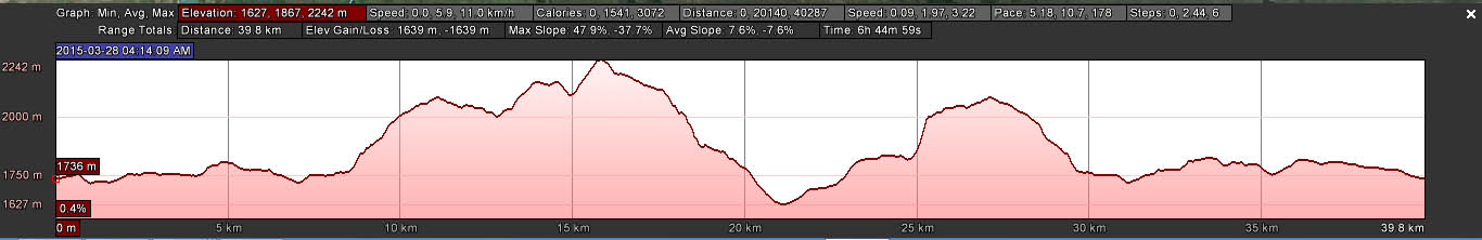

And the route:

Thank you to Peter Le Roux for the Google Map posted on the event group page.
My first was at Gilloolys, my old backyard. This is the newest parkrun; it only opened this past Saturday.

Gilloolys parkrun - 26:40

Runners on the other side of the dam
A crisp morning run - perfect temperature for a run. I know the property like the back of my hand and was very pleased to see how beautifully the far end of the course has been cleaned up and utilised.

Overall the route is a bit disappointing; there are definitely other options with better flow (without touching the ridge), especially considering that this is a high-volume parkrun. Their inaugural parkrun this past Saturday saw 975 people participating! Then again, I don't know what their land access and permission limitations were. Nonetheless, a good run on my old stomping ground and nice to run and catch up with running friend Joseph. He was in for all 9 so we ran together often.

Running with Joseph
From Gilloolys we headed South to the Alberton area.

Rietvlei parkrun - 28:20


I know the Rietvlei Zoo Farm property in the South of Jo'burg from orienteering; my first parkrun here. Their route signs are superb and include distance covered at 500m intervals. The clock at halfway was also a bonus, especially if you're chasing fast times and PBs.

Great route, excellent use of the area and nice mix of terrain.


Next up, Soweto!

Mofolo parkrun (Soweto) - 29:20


Without any local particpants nor the friendly run director and a rather odd route of loops, Soweto was a little bland. I ran again with Joseph and we had a good chinwag about stuff. And what would you know, Joseph is friends with my very dear and oldest friend, Allison. The things you discover when you run!

A number of friends have been out here for the parkrun, which has not been very well supported by locals. Apparently, the reason for this - my friends found out from the run director - is that there are funerals on Saturday and, for those that do run, 5km is too short. Pity. It's a nice park and parkrunning is a lovely community activity.

With Staci at Mofolo. Staci is the brains behind 9 Freedom Runs for Freedom Day.
We did indeed get stuck in funeral traffic on the way out of Soweto. Crazy! We made it just in time to stay on schedule for our next one on the West Rand.

Roodepoort parkrun - 29:40


This park is beautiful! With so many trees showing off their autumn colours, it really was a pretty sight.

I enjoyed the park but feel a lot more can be done with the route. On one hand, the existing two lap route is a no-brainer: an around-the-park run. But with such lovely trees, bridge over the stream and such a big area to utilise, it could be a little more exciting.

Thank you to Roodepoort parkrun for this photo.
I thoroughly enjoyed my run here and at the end met up with my running buddy Rob. He arrived a bit late so I hadn't seen him before the start. He came to do this one before a family lunch. He aimed to make the last one in Bryanston too (which he did - after dessert).

It was a quick drive from here and back across the ring road to the southern slope of Northcliff hill.

Alberts Farm - 31:26


I've always enjoyed Alberts Farm and have enjoyed using it over the years for orienteering, mountain biking, trail running workshops and navigation coaching.

I've heard complaints that parkrunners find the upper section too technical. I was surprised to find it very much not so. Compared to 10 years ago, the trails up top are as smooth as a baby's bottom. As far as technical goes, on a scale of 1 to 5, I'd give it a 2 at a push...

This is certainly one of the best routes around and it makes superb use of this lovely park. I ran mostly on my own, catching up with Chrissie later on.

The Alberts Farm parkrun crew had much appreciated bananas and water for us at the finish - thank you. I was quite relieved when the RD said that people usually take their normal parkrun time and add two minutes for a fair time at Alberts Farm. I did a 31:26 run here for my 5th of the day. Happy.

Next... off to Delta Park - the home of parkrun SA!

Delta Park - 31:37

Of all the parkruns, this is the only one I've run before - in the early days when there were only about 200 runners.

Again this is a venue I know very well from orienteering and from mapping the park. It is a good and solid route with some long steady climbs and glorious downhills. No photos from this one... my companion and supporter, my mom Liz was snoozing in our car!

Keeping it on familiar ground for #8 (my 7th), we headed north to another lovely orienteering park.

Golden Harvest Park - 33:49


The legs were starting to feel it - more the stop-start than the actual runs. And this one started with an uphill. I was pleased for it so that I could walk the hill and stretch my tight legs out after the car drive to the park.

I thought I knew Golden Harvest well. What a surprise to discover a section of the area that I've never been in before. Apparently there was a colour-coded O event on this section - like more than 10 years ago. It is stunning!


Brightness of day starting to fade.
I enjoyed that we had a few uphills, which I thoroughly enjoyed walking. This made my running sections faster and smoother. My legs felt great on the move but were definitely tightening up when stopped.

With Ian, Staci's husband.
Now off to our last location, Bryanston.

Bryanston parkrun - 30:27

My running buddy Rob made it for this one and I had such fun running with him. I very much miss our old weekly runs (and cup of tea afterwards). I was surprised by my time because it was the last (my 8th) and we chatted the whole way! It definitely helped to make the kilometres fly past.

This route along the Braamfontein Spruit is pleasant. I haven't been along here since our annual Dead of Winter Spruit run last year. The first half is mostly a lovely gentle downhill, flowing with the Spruit. The return works your legs.

It was a pleasant run with the number of Freedom Runners and parkrunners participating; it must be a nightmare with >1,000 people on Saturday mornings!

With Joseph, me, Rob, Chrissie and Dave.

Routes posted on the Facebook group.

What an awesome, awesome day of running. A wonderful celebration of our ability to run and our freedom to run. Old friends appreciated, new friends made, places discovered and a day most enjoyed. That was 40km for me; 45km for those who did all 9.

After a few errands, Liz and I headed back to Parys having clocked around 370km in the car (250km between JHB and Parys and over 100km driving around JHB).

Kisses and hugs to my mom (and Tansy) for spending the day on the road and in the parks with me. xxx

Thank you to Staci and Frances and Ian and all the RDs and people behind making 9 Freedom Runs for Freedom Day possible. I will so be there again next year. xxx

10 years ago - Swazi Xtreme 2006

One of the events of which I am still most proud was Swazi Xtreme 2006, which I did with Evan Price, Bruce Fordyce and David Vlok - one of a series of events for the Vlok & Fordyce tv programme.

Bets were against us to finish this 250km adventure race through Swaziland -  a notoriously tough one that I'd participated in since it started in 2001 - organised by Darron Raw. But, finish we did. The event wrapped up in 2010 after a decade of annual events.

It's 10 years to the day that we took part in this event and I got to know not only one of the icons in South African sport and running, but also an incredibly kind and warm-hearted man, Bruce Fordyce. It never ceases to amaze me, when I see Bruce at runs, how people gravitate to him. He always has a moment for a photo and a special word for runners - from novices to those that have been running for decades.

At the time I knew Evan from adventure racing. Young and strong, he enthusiastically joined the team and proved to be a fun (and funny) teammate and a superb navigator.

David Vlok was fresh off many years of staring in the tv soap, Egoli. I'd never watched it but from what I know his character was a nasty fellow. In person, David was a bit of a celeb on the outside and could come across as quite ego-y, mucho and even aggressive (he is not unfamiliar with bar brawls). But in reality, David is friendly and with a gentle nature and good humour. Although I see him rarely, I think of him with fondness. I'm not quite sure what he is up to these days; I think he and Bruce still see each other here and there.

Evan has been cycling around the world for just over a year. In December he biked through Syria and Iran. I'm not sure where he currently is. His blog is ontheroadtosomewhere.weebly.com.

Bruce, as you well know, is the father of parkrun in South Africa and still so much a part of Comrades and running culture.

If you're up for a bit of a read, my race report from Swazi Xtreme 2006 is still online. It's in a side directory on my www.AR.co.za website on a sub-site I built for the event.

Team Jungle before the start: David Vlok, Bruce Fordyce, me and Evan Price. 

Team Jungle at the finish: Bruce, Lisa, Evan and David.

Still clowns. As Bruce says, "From Swazi Extreme to parkrunning!" 10 years on. Lisa and Bruce yesterday.

Tuesday 26 April 2016

Spec-Savers Kids Right to Good Sight programme

I've been with a Spec-Savers in Jo'burg for many years so I was very pleased to see a Spec-Savers branch here in Parys.

Last week Thursday I popped into the branch to enquire about vision tests for children and making a booking. The friendly staff said that consultations for children under 12 were free of charge. A pleasant surprise. I made appointments for Kyla and Ruben for Friday. We knew that Kyla may have a vision deficit as she was tested a few years ago. This was to be Ruben's first optometrist visit.

Kyla does indeed need glasses and so after the test, we headed to the section to choose frames. They have an excellent range of children's frames and after narrowing it down to three, she chose her favourite. It was then that they told us that children's glasses are also free of charge up to the age of 12. Kyla is 10. How incredible!

I looked Spec-Savers up online and discovered their Kids Right to Good Sight programme, which provides free test and spectacles for children aged 6 to 12.

Ruben's consultation was smooth - and he learned about the inside of the eye too. His vision is perfect, so no glasses for him.

Spec-Savers, thank you. You've got customers for life.

From the Spec-Savers website:

An image

In 2008 we launched our kids Right to Good Sight campaign that has assisted over 193 243 South African children with FREE eye tests, Colour coded frames and Aquity prescription lenses, dramatically improving their lives forever.
Our pledge is to make a lasting difference in the lives of all children, so if you are in a school environment, and know of any kids 6 to 12 years of age who are in desperate need of spectacles, get them to contact their nearest Spec-Savers store to book a free vision screening test.

Tuesday 19 April 2016

Brown squiggly lines bring bliss

I know how to use OCAD - orienteering map-making software. I'm not the most proficient nor practised as I don't map very often - and I haven't mapped any seriously tricky terrain. I've modified other people's maps and I've drawn my own maps of schools and a park. I'm busy with my first river map (mapping the bank features and islands) and a map of a primary school here in Parys.

My next project is to create a basic orienteering map for Forest Run. It serves a couple of functions:

  • A hand-out to introduce participants to the delights of a map and knowing where you are. Yes, the route will be fully marked, but I like to think that runners may enjoy knowing where they are. Of course they can tuck it into their backpacks and leave it there...
  • A guide for my marshals (many of whom are orienteers) to get to their marshalling points - and for sweeping the route.
  • For safety: this special version for my marshals and medics will show escape routes and accesses.
  • The start of a wonderful map for technical, long-distance orienteering events and for rogaining, a long-distance, time-limited form of orienteering - my favourite-favourite.
For now, this will be a really simple map - I'm short on time and a complex map is not required just yet.

In order to create an orienteering map, one needs a base map. We generally use orthophotos, which have been corrected for distortion and they carry contour lines, which indicate elevation and topographical features. Google Earth screen shots do work - for small areas - but there are no contours. 

Fortunately, being in the modern age, we can get digital aerial imagery and also digital contour lines; both of which can be georeferenced and imported into OCAD.

I've never had experience with this.

Until today.

OMG! My heart runneth over with bliss. And I can give full credit to Stephanie, who supplied me with the necessary files - all beautifully georeferenced and ready to go. Sarah R and Paul were also on hand, offering assistance - thank you. Nic, with his OCAD experience, got me to the final stage of success tonight - getting my GPS track in.

And so it was that I successfully imported the contour line file. With counsel, I got the background images in (13 x image files at 285MB each!). And I've just experienced the joy that comes with importing a gpx file and successfully positioning it so that my track for the routes is in the correct place. Oh, what joy!

Now the work starts - to turn these squiggly lines into something that can be read and interpreted. 


Friday 15 April 2016

Altitude profiles are relative

In drawing the altitude profiles for the Forest Run routes last night, I had to decide on the best way to present the route. What kind of elevation scale was I going to use?

The challenge is to indicate that there are climbs and descents - some of which are steep; but not horrendously so. Out here in the Vredefort Dome, there isn't anything too nasty, other than the sting-in-the-tail descent near the end. No climb nor descent goes on and on; but they're still there to test you.

I plugged my gpx track into Google Earth and also used two online apps to compare profiles and also for them to calculate cumulative climb. Although the results vary, I think approximately 1330m of cumulative gain is fair for the 46km route at Forest Run.

Here is my profile for the 46km route:


So, how does Forest Run compare?

Well, Dorothy, we're not in the Drakensberg Mountains, the Witteberg Mountains nor on Table Mountain. But we've still got some climb.

Distance (km) Cumulative climb (metres) average climb (m/km)
Forest Run 46 1330 29
Rhodes Run 52 1380 27
Skyrun Lite 65 2400 37
Drakensberg Northern Trail 40 1640 41
Ultra Trail Cape Town 35 1800 51
The Otter 42 2400 57


I couldn't make a profile for Ultra Trail Cape Town as they don't show a y-axis elevation scale on their altitude profiles. I did grab profiles from these other events - and I've scaled them appropriately to compare. That's Forest Run with the grey shading.


The thing with cumulative climb values for events is that ascents are... cumulative.

Looking at my average climb (metres per kilometre) calculation, The Otter beats all the others for its up-down-up-down of its route, even though it doesn't have the massive and steep ascent of Skyrun Lite nor the big climbs of Drakensberg Northern Trail. Rhodes Run, like Skyrun Lite, also has a big climb, some stuff in the middle and then a long and steep descent.

Of these runs, I've done Skyrun, Rhodes Ultra and Forest Run. For sure, Skyrun is the toughest on the legs and lungs on the ascents; and that's a long long long steep steep steep drop into Balloch. It also has some wicked thigh-burning climbs in the middle.

Could this Forest Run route be harder than Rhodes? Mmm... It has been a long time since I did Rhodes and I had a superb day out there so even considering Rhodes' Mavis Bank and the drop into the hamlet of Rhodes... Definitely not an apples-with-apples comparison.

Climb really is so different on the legs if you have one big climb or lots of smaller ups and downs.

Also, it isn't only the elevation that makes a route challenging, it is also the underfoot terrain.

And how hard you're pushing.

And the actual elevation (height above sea level) of the route. There's a big difference in scaling a steep ascent at 2500m than at sea level.

Here are the altitude profiles for these same events, as presented on their websites. Take note of the elevation scale on the y-axis.

Drakensberg Northern Trail - recent host to the SA Trail Champs. 40km. Each elevation mark is at 250m intervals.

Rhodes Run. 52km. Elevation is in 100m intervals. This looks like you climb Mavis Bank on all fours... Oh, wait, some people do!

Skyrun Lite 65km (route ends at Balloch, in the dip before the spike at the end). Elevation is in 500m intervals. Looks a lot more tame here than on my profile scale.

The OTTER. 42km. Elevation is in 10m intervals. Very spikey, which ever way you look at it.
Of course, I could have presented a more flattened profile for Forest Run - I think this actually looks more like reality if you're looking at the hills.


Next time you look at an altitude profile, don't stress if you see big bumps. Take a look first at the altitude interval on the y-axis and compare to something you've done before to put it into perspective.

Altitude profiles really are an indication - not a definitive guide to the difficulty of an event.

Regardless of the climb, you've got to do the distance. So just jump in, enter and enjoy the experience of the route, terrain and scenery.

Tuesday 12 April 2016

Happy 15th Birthday www.AR.co.za

I was snoozing a bit yesterday so this is a one-day late HAPPY BIRTHDAY to www.AR.co.za
www.AR.co.za turned 15 YEARS OLD yesterday!
I started the site back on 11 April 2001 to provide a central avenue for everything AR in South Africa. I started building the site in mid-2000, but only put it live on 11 April 2001.
Back then the site was built in straight HTML with dozens of pages that I hand-coded in notepad! Later, I put the site into CSS style sheets and then later onto the WordPress platform that it currently runs on.
Although the event calendar has been a focus, there’s an abundance of articles (over 100), most of which I’ve written over the years, covering everything from basics, to seconding, medical issues, navigation and teammates. There have also been hundreds of event reports, written by you, from an array of events.
The national ‘advracesa‘ email group list… I set up the email list on 27 June 2001. Oddly, I thought the email group was older… but that’s probably because I was administering a number of others at the tme. There are currently 903 members – some have been on this group for more than a decade!
Looking at the current member list (I cannot account for early adopters who have left over the years), Mark Le Roux was the first to join on 28 June 2001; Darron Raw was second on 29 June 2001. Some other names you’ll recognise may include Francois Oosthuizen and Tim Skeep (2 July 2001), Piers Pirow and Erica Terblanche (20 August 2001) and Nicholas Mulder (14 September 2001). Expedition Africa director Stephan Muller joined the list on 21 May 2002.
tick-tock… the years have been full of adventures and adventure races.
Three cheers for another 15 years!
Lisa (AR’s mom)

Sunday 10 April 2016

Up, up and away in a hot air balloon

This morning I had the pleasure of going hot air ballooning!

There is quite a bit of ballooning that goes on around here - totally understandable when you see the area. We've got lots of open fields (with road access) for take offs and landing as well as the scenic Vaal River and Vredefort Dome to look down on.

This morning I was up before 5am to meet at a place a few minutes from town. The air was still. Like totally still. The test balloon went straight up. Today was never going to be a distance outing.

I thoroughly enjoyed helping Felicity (pilot) and Rich (pilot) to get their kit ready and balloons inflated. Everything, from the basket to the gas tanks and balloons, is sooooo heavy! These are small baskets that can hold three people (possibly four at a squish?) and it takes a few of us to move one. I don't even think that four people could lift a basket? We tilt them to move them around and to get them on and off the trailers. And these balloons are 'small', as far as balloons go. Imagine how big a balloon must be to lift one of those huge baskets that can carry 12-odd people? !

It was really cool when the fans started to blow air into the balloons. They lie horizontal on the ground as they inflate.

Sunrise happenin'

This is Rich inside the balloon, securing the crown. He is there - to the right of the round  yellow centre circle. And this is a 'small' balloon!
Then the burners blast heat into the balloon and it rises, tilting the basket upright.

Felicity in her basket.
I was in the basket with Rich and we took off smoothly. With absolutely no wind, we knew from the outset that this would not be a day for distance; but we did hope to get to the Vaal River at least.

We took to the air first. Looking down on Felicity's balloon.
Alas, it was not to be. We caught some very light breezes but pretty much got no more than 500 metres from where we started. It was very misty and I really enjoyed looking out at the Vredefort Dome, towards the hills that I've spent so much time in recently for Forest Run planning.

Felicity in the air.
Looking towards the Vaal. Mist all around. No river in sight.
Our shadow.
We tried for a while to catch a breeze at different heights and then drifted back towards where we set off. We landed in a field about 300 metres straight-line from where we started. This was really easy for Sylvia and the friendly guy who was staying at the venue - they were driving the vehicles with the trailers to fetch us.

It is heavy and warming work to deflate the balloon and to pack everything up. The weight is everything is really quite incredible.

Two curious horses and two curious donkeys came to see what we were up to in their field.
It was a good experience to go hot air ballooning. It really is quite remarkable and would make for an amazing, practical physics class - this whole hot air rising thing; as well as volumes and weights. It must be very exciting to fly distances on strong winds and also to great heights. I look forward to other opportunities.

My thanks to Sylvia for inviting me and to Felicity (pilot), Rich (pilot) and Koos (I really don't think this is his real name!), who warmly welcomed me.

Friday 8 April 2016

You're a name, not a number

Online entry systems are really useful because they take care of admin behind the scenes. With a system like this, event organisers can just download a spreadsheet with names of entrants and that's it done.

But, for me, there's a problem with this...


If your entry has gone through an online system, I don't feel like I know you. You're a name on a list that I'll probably download close to the event date.

I used an online system for my first two Forest Run events (I was using it for other events) and it works well. The system definitely takes a load off... but, I end up on race day not really knowing who has entered. I see the names on the list but I don't SEE the names. Last year I really enjoyed interacting directly with runners.

Going into this Forest Run I decided from the outset to handle all entries manually again. Sure, there is more admin and emails and comms... but from these I get pleasure. In meeting you, the entrants - old and new. By the time you rock up at the race, I've spoken to you on email, I've looked through your entry forms. I know how old you are and where you're from.

To me, you're more than a name on a spreadsheet to which I assign a race number. You're a Forest Runner.

Then, when I greet you at the finish line, I'm so totally proud of you. Because I've met you. Even if just through an email and your entry form.

Running my own Metrogaine event

I had an absolute treat on Wednesday night - an opportunity to be a participant in my own Metrogaine event. It was hosted from Fred Richardson's Mindful Runner store in Emmarentia.

A few months ago, Christie Courtnage, a young and experienced orienteer, asked if she and Timothy Chambers (another orienteer) could organise the annual April Metrogaine, especially as I've moved from Jo'burg so logistics are a bit more challenging. I immediately agreed.

Christie is based in Jo'burg; Tim is studying in Cape Town, so he assisted with clues during his varsity holidays. What a superb event they planned! Spot-on control placement and excellent clues.

They also had some excellent 'carrots' - high point-score controls and an excellent points distribution that you really had to think about. Very many options out there.

Wednesday was a cold and wet night - the coldest we've had in many, many months. My teammate wasn't keen to run in the rain (I don't blame her!) so I headed out on my own. I wasn't sure going into it how well I'd be running, considering that I had 50km in my legs from the day before.

I felt like a champ! The cooler temperatures really make a difference. I even ran the hills! Initially I was a bit too hot with my shell on, but after 90 minutes when the rain was coming down more, I then started to really feel the chill.

This is what my route looked like:

 Although my route had good flow, I did make a few mistakes.

Early on, I should have gone to #22 before #23. Plenty close enough.

I went 33, 34, 66, 37, 35... I could have gone 33, 34, 35. My map was folded over and I hadn't quite seen 35. My plan wasn't to go back past 35 but to possibly head to 46. As it happened, I was short on time and so hitting 35 as I did actually worked out fine.

I should have zapped the controls at the top of the map and left the ones on the side of #66.
That said, not knowing how my legs were going to feel, I didn't want to run too far away and then have to get over the hill to get back. I decided from the beginning not to go up there even though the points score would have definitely been far more favourable.

Metrogaine really is a super fun event. There's a definite thrill in running around the suburbs at night, claiming them for our own recreation and enjoyment. Night is, for me, a magical time of day. I also took great delight in seeing headlamps of other runners criss-crossing roads and saying hi to them when we passed each other.

We've got some other maps and routes and results on our Metrogaine Facebook page. The Strava fly-by is a really cool one to check out as you can watch the tags moving as the people run around.

My thanks to Christie and Tim for their excellent planning, to Denise for handling the admin and entries, to Brian for his event support; to Fred for opening his store doors to us, for the local Buck & Hog for letting us use their loos and supplying post-run colddrinks. We also enjoyed some samples of flavoured coconut water from Denise's connection. A special thank you too to Vix - I stayed over with her. An excellent team for a most wonderful evening. Thank you.

Wednesday 6 April 2016

Forest Run 46km thru run

When I go out scouting tracks and paths for routes, I cover a lot of ground. I check out this trail, that animal track to look for options and connections. Over the past three months, I've covered almost 200 kilometres of trails in the Vredefort Dome. My GPS tracks look like a spider web.

Not all of these tracks are useful. When I construct a route it has to have logical flow, the direction must be pleasing (scenery) and the intensity of the trails must vary.

After each scouting outing I colour-coded my tracks with green being easy-running sections, yellow for runnable sections that require concentration, orange for sections that are technical and slow runnable (I may or may not run them) and red for those sections that I would definitely not run.

Only then did I looked at connecting these tracks to make exciting routes with good doses of green, yellow and orange plus aiming to limit the amount of red - of which there is much available.

On computer, I end up with routes but they've been done in sections, which I may have originally done in the opposite direction as the planned route.

Yesterday I headed out to run the thru-route of the 46km, which includes the 16km (minus a short section that I have done in the past - in the right direction) and the 30km routes.

I only set off at around 08h30 and took it nice and easy, knowing that I had a full day ahead. My running training this summer has been the worst of my life, so with limited kilometres in my legs, I didn't want to push it too hard, too early.

Conditions were perfect as it was cool, overcast and later in the afternoon there was light drizzle.


Even so, I had to be very conservative with my water as there is nowhere to fill up until the furtherest end of the route. Being low on water for a long time was challenging, even though conditions were mostly cool. I was very relieved to get to a cattle trough.

I checked the JoJo tank for a tap. Nada. The flow into the trough is regulated by a toilet cistern-like system. Nice, fresh water. I didn't want to chance it so I did add a water purifying tablet to my reservoir. When I got to Warrin he told me that the water is clean, borehole water and is good to drink straight.
 There has been a lot of growth in vegetation over the past few weeks. We did get some rain in March and the plants responded.

Same area, almost exactly two months apart. This is a section with an old unused trail so it was difficult to follow in Feb. Near impossible now.
I'll be out there in the weeks before Forest Run to trim the route. This will mean weed eating sections like this so that participants can actually see where they're running and what they're putting their feet on. For me it is a way to 'mark' the route - a clear track is the only option for runners to take.

Company.

Pretty.

Warrin's horses on top of a ridge.
I lost a good deal of time in 'stopped time', which was consumed when I stopped at a number of places to send text message back to my safety followers. Stopping means backpack off, open it up, dig out zip-locked phone, check for signal, send messages, wait for send, pack everything back, get going again. Stopping to fill up at the trough took a while and another big fill an hour later. And then a later chatting stop near the end. Total stopped time was 1h30.

I also messed up two sections of the route (I was trying to do it all from memory) and lost probably an hour with these. These messes alter my distance log. I logged a total of 48.5km. For the actual route, this would be no more than 47km.

My moving time was 8h23 so I think it fair to adjust moving time to 7h20 or so. I took it way chilled and walked all the ups. I ran (very chilled and easy pace) the runnable flats and downs. With playing with my map and GPS, I'd say that I was probably moving just a bit quicker (I know the terrain) than a back-of-the-pack runner.

The open 4x4 track sections are divine to run. I definitely reeled in the time here. There are a few sections of really technical rocky terrain, like the sting-in-the-tail descent near the end. These are, for me, slow going because I'm really cautious on stuff like this. And I definitely lost time with all my walking and messing around.

I'm very happy with the route. It has a good balance. The nature of the area means that it is not easy out there. 46km is a decent distance - off-road - any way you look at it. Accumulated elevation is a bit over 1420m.

I made it through to the end just before dark. A very good day.

Pretty sunset colours bouncing off clouds on the opposite side.