The challenge is to indicate that there are climbs and descents - some of which are steep; but not horrendously so. Out here in the Vredefort Dome, there isn't anything too nasty, other than the sting-in-the-tail descent near the end. No climb nor descent goes on and on; but they're still there to test you.
I plugged my gpx track into Google Earth and also used two online apps to compare profiles and also for them to calculate cumulative climb. Although the results vary, I think approximately 1330m of cumulative gain is fair for the 46km route at Forest Run.
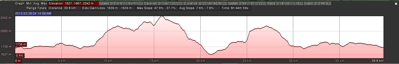
Here is my profile for the 46km route:

So, how does Forest Run compare?
Well, Dorothy, we're not in the Drakensberg Mountains, the Witteberg Mountains nor on Table Mountain. But we've still got some climb.
| Distance (km) | Cumulative climb (metres) | average climb (m/km) | |
| Forest Run | 46 | 1330 | 29 |
| Rhodes Run | 52 | 1380 | 27 |
| Skyrun Lite | 65 | 2400 | 37 |
| Drakensberg Northern Trail | 40 | 1640 | 41 |
| Ultra Trail Cape Town | 35 | 1800 | 51 |
| The Otter | 42 | 2400 | 57 |
I couldn't make a profile for Ultra Trail Cape Town as they don't show a y-axis elevation scale on their altitude profiles. I did grab profiles from these other events - and I've scaled them appropriately to compare. That's Forest Run with the grey shading.

The thing with cumulative climb values for events is that ascents are... cumulative.
Looking at my average climb (metres per kilometre) calculation, The Otter beats all the others for its up-down-up-down of its route, even though it doesn't have the massive and steep ascent of Skyrun Lite nor the big climbs of Drakensberg Northern Trail. Rhodes Run, like Skyrun Lite, also has a big climb, some stuff in the middle and then a long and steep descent.
Of these runs, I've done Skyrun, Rhodes Ultra and Forest Run. For sure, Skyrun is the toughest on the legs and lungs on the ascents; and that's a long long long steep steep steep drop into Balloch. It also has some wicked thigh-burning climbs in the middle.
Could this Forest Run route be harder than Rhodes? Mmm... It has been a long time since I did Rhodes and I had a superb day out there so even considering Rhodes' Mavis Bank and the drop into the hamlet of Rhodes... Definitely not an apples-with-apples comparison.
Climb really is so different on the legs if you have one big climb or lots of smaller ups and downs.
Also, it isn't only the elevation that makes a route challenging, it is also the underfoot terrain.
And how hard you're pushing.
And the actual elevation (height above sea level) of the route. There's a big difference in scaling a steep ascent at 2500m than at sea level.
Here are the altitude profiles for these same events, as presented on their websites. Take note of the elevation scale on the y-axis.
 |
| Drakensberg Northern Trail - recent host to the SA Trail Champs. 40km. Each elevation mark is at 250m intervals. |
 |
| Rhodes Run. 52km. Elevation is in 100m intervals. This looks like you climb Mavis Bank on all fours... Oh, wait, some people do! |
 |
| Skyrun Lite 65km (route ends at Balloch, in the dip before the spike at the end). Elevation is in 500m intervals. Looks a lot more tame here than on my profile scale. |
 |
| The OTTER. 42km. Elevation is in 10m intervals. Very spikey, which ever way you look at it. |

Next time you look at an altitude profile, don't stress if you see big bumps. Take a look first at the altitude interval on the y-axis and compare to something you've done before to put it into perspective.
Altitude profiles really are an indication - not a definitive guide to the difficulty of an event.
Regardless of the climb, you've got to do the distance. So just jump in, enter and enjoy the experience of the route, terrain and scenery.
No comments:
Post a Comment